
| DIRECT LINKS TO DATA SOURCES |
Mono Basin plant collection locations by Tom Schweich
USGS contacts:
Carol Ostergren
US Geological Survey National Geospatial Program
3020 State University Drive East, Suite 4003
Sacramento, CA 95819
916-278-9510
916-278-9473 (fax)
costergren at usgs dot gov
Drew Decker
USGS Geospatial Liaison for California
NSDI Partnership Office, U.S. Geological Survey
4165 Spruance Road, Suite 200
San Diego, CA 92101
619-225-6430
619-417-2879 cell
619-225-6101 fax
ddecker at usgs dot gov
National Atlas Raw Data Download / Map Maker
USGS Earth Explorer - Download aerial photo mosaics and more!
National Aerial Photography Program
USGS Seamless Data Distribution System - download DEMs
Eastern Sierra Interagency Land Tenure Project - examining land ownership adjustment opportunities
Web Soil Surveys / Soil Data Mart - NRCS
 Eastern Sierra Geospatial Data Clearinghouse - a project of
WMRS (White Mountain Research Station) and ESGN
(Eastern Sierra GIS Network).
Metadata
Eastern Sierra Geospatial Data Clearinghouse - a project of
WMRS (White Mountain Research Station) and ESGN
(Eastern Sierra GIS Network).
Metadata
California
Spatial Information Library - California GIS maps online
CERES Geofinder
California Digital Conservation Atlas
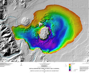
USGS Digital Bathymetric Model of Mono Lake, California
Landsat / Bathymetric Map of Mono Lake, by Christian Raumann, USGS. An example of some of the graphics not published with the bathymetric map above.
USFS - Inyo National Forest
List of data sets
![]() (14K)
(14K)
Contact: Laurie
Otterman
Cartographic Technician
Bishop, CA
(760) 873-2400
August 26,
1998 Mono Lake Shoreline Map (1MB)
Contact: Tom Potter, GIS Analyst
Geometronics, Public Use and Facilities
USDA Forest Service, Region 5
1323 Club Drive
Vallejo, CA 94592
(707) 562-8893
thomaspotter@fs.fed.us
USFS - Pacific Southwest Region
GIS Clearinghouse
BLM - Bishop Resource Area
Bishop, CA
(760) 872-4881
LADWP
Eastern Sierra Environmental Issues
(213) 367-1128
Mapquest
Free
digital USGS topo maps of the Mono Basin
Microsoft Terraserver
Black
and white photo mosaic of the Mono Basin
Mono County
Geographic Services
Parcel Viewer
List of data coverages
![]() (13K)
(13K)
Contact: Nate Greenberg or
Dustin Clark
P.O. Box 1121
Mammoth Lakes, CA 93546
(760)924-7746
Talon Associates
List of
resources for the Eastern Sierra Nevada Region
Contact: Nate Greenberg: nate @ talonassociates.net
P.O. Box 1121
Mammoth Lakes, CA 93546
(760)924.7746
California Fire and Resource Assessment Program
List of
data available
California State Lands Commission
GIS data available - Mostly
coastal resources, except National Wetlands Inventory for California.
Sierra Nevada Ecosystem Project
Digital Spatial Data
Archive
Digital
Spatial Data Catalog
Map/Data
Site
SAGEMAP - A GIS Database for Sage Grouse and Shrubsteppe Management in the Intermountain West
Fairchild
Aerial Photography Collection at Whittier College
1929, 1930, and 1954 photos of the Mono Basin
PhotoMapper Aerial Photos
of Mono Lake and Tributary Streams
1999 color-infrared
2000 color
2001 color
2002 color
Contact: IK Curtis (818)
842-5127
Worldwind - NASA 3D landscape visualization program
Google Earth - 3D aerial photos
Cartograph.com - NetMAP Online GIS Network
| LISTS OF DATA SOURCES |
USGS
Internet
Data Sources
GIS Data for Water Resources
The largest free geo-spatial data repository on the
web
www.GisDataDepot.com
GIS.com
Links to GIS data
sources
The Geography Network
Links to GIS
data sources
California Environmental Information Catalog
Metadata
records by catalog title
ArcData Online
GIS data on
the Web